I’ve always been obsessed with watching storms roll in from my porch, but recently, I stumbled down a rabbit hole of atmospheric science that completely shattered my understanding of what Mother Nature is capable of. We all know about tornadoes, hurricanes, and blizzards, but the world is actively hiding atmospheric anomalies so strange, they look like CGI from a sci-fi movie.
I was genuinely shocked to learn that in some corners of our planet, lighting storms never end, clouds mimic alien spacecraft, and icicles act like living, deep-sea assassins.
When I started researching these bizarre weather phenomena, I expected to find some mildly interesting cloud formations or rare rainbows. What I found instead were terrifying and beautiful events that scientists are still struggling to fully explain.
National Geographic, our atmosphere is essentially a massive, chaotic chemistry lab where temperature, pressure, and moisture occasionally align perfectly to break the rules of reality. Prepare yourself, because what fascinated me most about these examples is that they happen right here on Earth.
What Causes the Strangest Weather on Earth?
The strangest weather on Earth is typically caused by extreme, hyper-localized combinations of atmospheric pressure, unique topography, and rapid temperature shifts. When specific environmental triggers—like sub-zero freezing rates, high altitude static friction, or hypersalinity—interact unpredictably, they produce rare meteorological anomalies that seem to defy standard physics.
Comparing Earth’s Rarest Atmospheric Events
Before we dive into the deep end of the list, I wanted to give you a quick visual breakdown of the strangest things happening in our skies and oceans. This comparison highlights just how varied these mysteries really are.
| Phenomenon | Location | Primary Cause |
|---|---|---|
| Catatumbo Lightning | Venezuela | Topography & Methane |
| Brinicles | Antarctic Ocean | Hypersaline Freezing |
| Volcanic Lightning | Active Volcanoes | Ash Particle Friction |
| Blood Falls | Antarctica | Oxidized Iron Brine |
1. The Never-Ending Storm: Catatumbo Lightning
Imagine a thunderstorm that virtually never ends. Above the mouth of the Catatumbo River in Venezuela, a relentless, silent light show illuminates the night sky for up to 160 nights a year. I was completely mind-blown to discover that this single location experiences up to 280 lightning strikes per hour, sometimes lasting for ten hours straight. It is the single most concentrated lightning hot spot in the world.
The science behind this localized tempest is a brilliant collision of geography and atmosphere. Warm, moist winds from the Caribbean Sea are pushed into a three-sided mountain basin. As this warm air hits the cold mountain drafts at night, it creates immense instability, generating colossal cumulonimbus clouds. For years, scientists falsely believed methane from nearby oil fields fueled the intense charge, but it turns out the unique topography alone is enough to create this terrifying, beautiful, and near-constant electrical storm.
2. The Ice Finger of Death: Brinicles
This one surprised even me, mostly because it sounds like a creature from a horror video game rather than a meteorological event. Beneath the frozen surface of the Antarctic ocean, a deadly, descending stalactite of ice occasionally reaches down toward the sea floor. Known as a brinicle, this underwater ice tornado freezes everything in its path, trapping slow-moving bottom feeders like sea stars and urchins in a literal web of icy death.
It happens because when sea water freezes on the surface, it expels its salt, creating a pocket of super-chilled, hypersaline brine. Because saltwater is denser than fresh water, this heavy, freezing brine sinks rapidly through the warmer ocean water below. As it sinks, it freezes the surrounding seawater, creating a hollow tube of ice that crawls toward the ocean floor. Watching time-lapse footage of a brinicle touching down and instantly freezing sea creatures in their tracks gave me absolute chills.
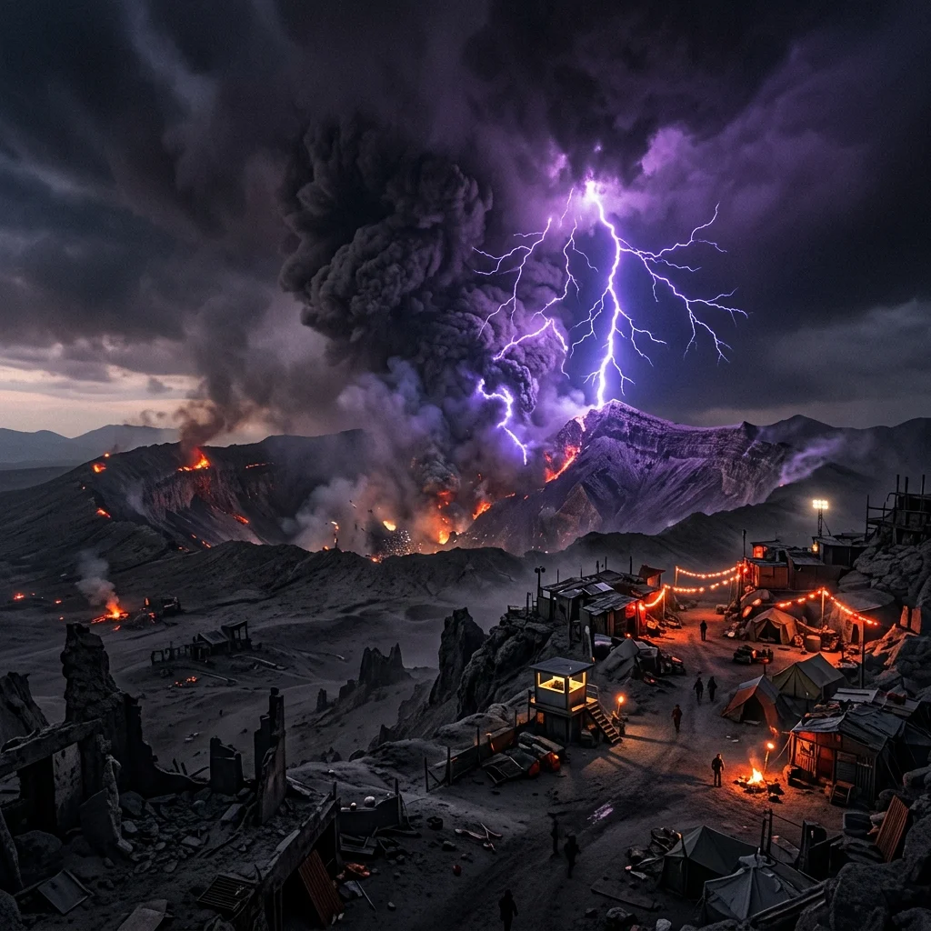
3. Dirty Thunderstorms: Volcanic Lightning
When you think a volcanic eruption is apocalyptic enough on its own, nature decides to throw purple and blue lightning into the massive column of ash and fire. Volcanic lightning, often terrifyingly referred to as a “dirty thunderstorm,” occurs right in the heart of an erupting volcano’s ash plume. It honestly looks like the opening of a portal to another dimension, and the physics behind it is surprisingly counter-intuitive.
Unlike normal thunderstorms where ice crystals collide to build electrical charges, volcanic lightning is born from violent friction. As the volcano erupts, billions of microscopic rock fragments, ash particles, and ice collide with immense force. These collisions strip electrons from the particles, creating massive static charges in the thick plume.
When that charge releases, it tears through the ash cloud in blinding streaks of lightning. It’s essentially the same static electricity you get from rubbing your socks on a carpet, multiplied by a billion.
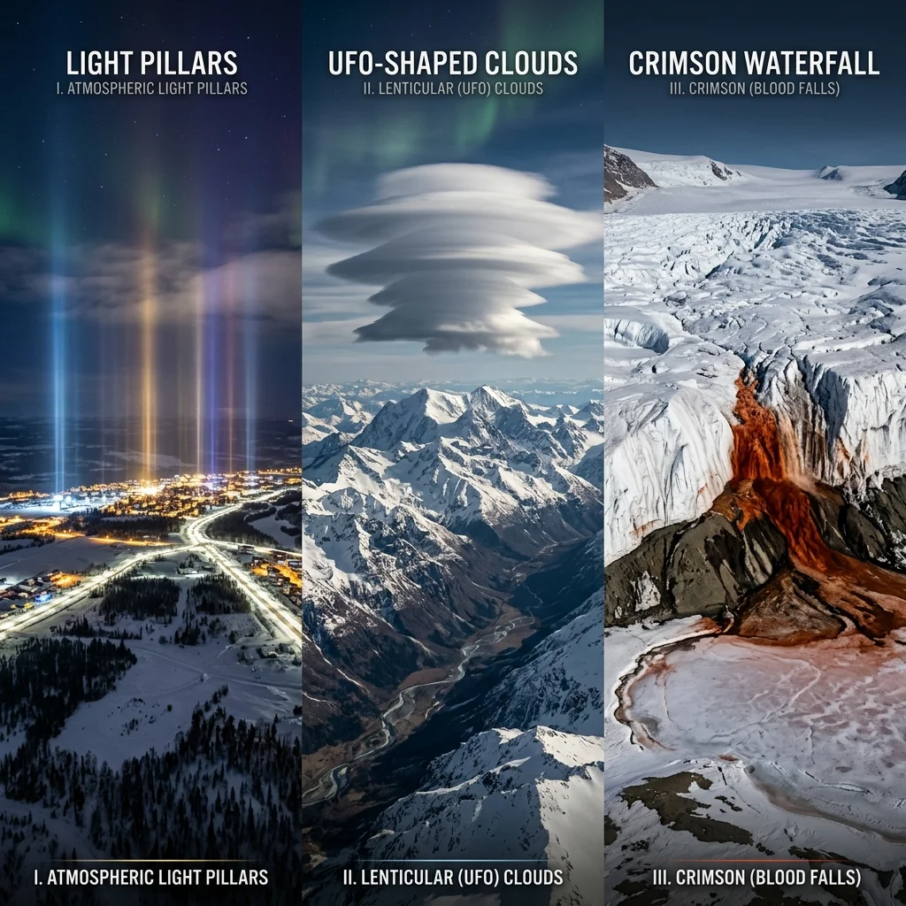
4. The Gruesome Illusion: Blood Falls
Deep in the pristine, blinding white landscape of Antarctica’s McMurdo Dry Valleys, there is a glacier that appears to be bleeding out. I remember seeing a photograph of the Taylor Glacier and assuming it had to be manipulated. A striking, dark crimson waterfall flows out of the pristine white ice, violently staining the frozen lake below. It looks like a crime scene on an epic scale, earning it the very appropriate name: Blood Falls.
For decades, researchers thought the red color was due to a rare species of red algae. However, the truth is much stranger, feeling almost alien. edu/” target=”_blank” rel=”noopener noreferrer”>Smithsonian, the waterfall is actually the discharge from a subterranean lake that has been sealed off from the atmosphere for over a million years.
This ancient water is incredibly rich in iron and completely devoid of oxygen. The moment this hyper-salty, iron-rich water hits the outside air, the iron instantly rusts, turning the water a brilliant, disturbing blood-red.
5. Sky Tubes: Morning Glory Clouds
If you look up at the sky in Northern Australia during the fall months, you might see what looks like a massive, rolling highway suspended in the atmosphere. Known as Morning Glory clouds, these perfectly cylindrical cloud tubes can stretch over 600 miles long and travel at speeds of up to 35 miles per hour. Watching one approach the coastline genuinely feels like you are looking at the underside of an alien mothership.
What fascinated me most about these clouds is that they are incredibly rare and almost impossible to predict anywhere else in the world, yet they reliably happen in the Gulf of Carpentaria. They are formed by a complex “solitary wave” in the atmosphere, caused when sea breezes from two different coasts collide over a peninsula, pushing the air upward into a continuous rolling motion. It essentially creates a massive, horizontal tornado made entirely of gentle, rolling fog.
6. The Neon Laser Show: Light Pillars
During brutally cold winter nights in extreme northern latitudes, the sky sometimes transforms into what looks like a massive, colorful barcode. Hundreds of perfectly vertical, glowing beams of light shoot up from the horizon directly into the stars. For centuries, people thought these “light pillars” were spirits or messages from the divine. Even today, they are one of the leading causes of UFO sighting reports in wintery regions.
The reality is an incredible optical illusion created by tiny, hexagonal ice crystals suspended in the freezing air. When the temperature plummets but there is no wind, these flat ice crystals slowly drift toward the ground, lying perfectly horizontal.
When light from streetlamps, cars, or even the moon hits the bottom of these millions of floating microscopic mirrors, the light reflects straight downward into your eyes. You aren’t actually seeing a beam of light going up into space; you are seeing a massive mirror reflecting ground light back down at you.
7. The Unsolved Mystery: Hessdalen Lights
While science has managed to explain most of the strange things happening in our skies, the Hessdalen Valley in Norway remains a frustrating, baffling anomaly. Since the 1930s, locals and scientists alike have reported seeing massive, glowing orbs of yellow, white, and red light floating gracefully through the valley. Sometimes they hover in place for an hour; other times, they zip across the sky at breakneck speeds before vanishing.
What makes this entry truly shocking is that despite decades of rigorous study, multiple permanent observation stations, and endless radar tracking, the scientific community still cannot agree on what causes them. The most prominent theory suggests that the valley itself acts like a massive natural battery. The rocks on one side of the river are rich in copper, while the other side is rich in zinc and iron.
It’s theorized that sulfurous water acts as an electrolyte, occasionally discharging huge bubbles of ionized gas (plasma) into the air. But to this day, it remains an unproven, brilliant mystery.
8. Fields of Daggers: Penitentes
High up in the dry, unforgiving altitudes of the Andes Mountains, you will find snow fields that have aggressively transformed into thousands of jagged, upward-pointing daggers. Known as Penitentes—named because they resemble crowds of people kneeling in penance—these razor-sharp spires of snow and ice can grow up to 15 feet tall. Trying to walk through a field of these icy blades is virtually impossible and incredibly dangerous.
The science of how these form is rooted in extreme environmental conditions. Because the air in the high Andes is incredibly dry and the sun is fiercely hot, the snow doesn’t melt into water. Instead, it undergoes sublimation—meaning it turns directly from solid ice into water vapor.
As small dimples form in the snow from the intense sunlight, the curves of the dimple reflect heat downward, accelerating the sublimation in the depressions while leaving the sharp peaks untouched. Over weeks, this creates a terrifying forest of ice daggers.
9. The UFO Illusion: Lenticular Clouds
If you’ve ever seen a photograph of a perfectly smooth, saucer-shaped disk hovering menacingly over a mountain peak, you aren’t looking at a government conspiracy. You are looking at a lenticular cloud. These stunning formations are the prime suspects behind almost every major UFO sighting near mountain ranges worldwide. They look completely solid, defying the fluffy, chaotic nature of normal clouds.
Lenticular clouds are essentially standing waves in the atmosphere. When strong, stable winds hit a massive obstacle like a mountain, the air is forced to flow up and over the peak in a wave-like motion. If the air is moist enough, a cloud forms at the very crest of that invisible wave.
The crazy part? The wind is violently rushing through the cloud at high speeds, constantly forming the cloud at the front edge and evaporating it at the back, giving the terrifying illusion that the saucer is hovering completely motionless in the sky.
10. The Sky on Fire: Circumhorizontal Arcs
To cap off this wild list, we have something that looks less like a storm and more like an oil painting spilled across the heavens. Commonly called a “fire rainbow” (though it involves neither fire nor rain), a circumhorizontal arc looks like a massive, brilliant brushstroke of vibrant rainbow colors painted flat against the high altitude clouds. It is, without a doubt, one of the most stunning atmospheric optic events a person can witness.
To see one, the conditions must be punishingly exact. First, the sun must be very high in the sky—at least 58 degrees above the horizon. Second, high-altitude cirrus clouds must be present, filled with perfectly aligned, plate-shaped ice crystals. When the high sun hits the vertical side of these ice plates and exits out the bottom face, the crystal acts like a perfect prism, scattering the light into a brilliant, fiery spectrum of color that spans the sky.
Nature Never Disappoints
After diving deep into the science behind these events, I’ve realized that the Earth is a far more dynamic and chaotic place than our daily weather forecasts suggest. While some of these events terrify me—I’m looking at you, ice finger of death—they all serve as a beautiful reminder of the complex physical laws governing our universe. It is staggering to think about how many unexplainable things are happening right above our heads while we are busy looking at our phones.
The next time you walk outside and see a weird cloud or an unseasonable storm, just remember: it could be much, much weirder. If you enjoyed learning about these atmospheric oddities, you’ll definitely want to check out my post on other incredible bizarre natural phenomena that will make you question reality.
Frequently Asked Questions
Are any of these strange weather events dangerous to humans?
Yes, several of them are highly dangerous. Volcanic lightning and the Catatumbo lightning storms pose extreme electrical risks. Additionally, fields of Penitentes are incredibly hazardous to navigate for mountaineers due to their sharp, unstable nature.
Can lenticular clouds produce rain or storms?
Generally, no. Lenticular clouds are usually non-precipitating clouds. However, they indicate high atmospheric instability and severe turbulence, making the air around them very dangerous for aircraft.
Has the mystery of the Hessdalen Lights been solved yet?
No, despite decades of rigorous academic study and permanent tracking stations, scientists still do not have a universally accepted explanation for the Hessdalen Lights, leaving them one of the few true atmospheric mysteries.
For more on this topic, visit National Geographic and Smithsonian Magazine.